Erie Lackawanna
Railfan.net 'erielack' E-Mail List Photo Archive

bigmapJGfinal2.jpg   Original: 1050 by 1195 pixels - Current: 1050 by 1195 - 100%
                          Try your mouse wheel too!

From: "JG at graytrainpix" graytrainpix AT hotmail DOT com
Date: Fri, 02 Sep 2005 00:03:50 -0400
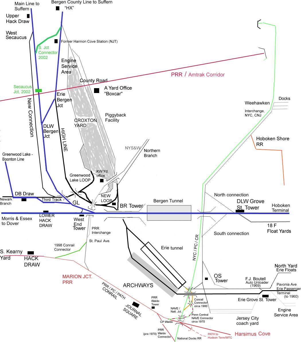
Subject: CROXTON / JC MAP - one more try
"bigmapJGfinal2.jpg" - image/jpeg, 184708 bytes, 1050x1195 (24bit)

As to get my mind off of those terrible scenes from Louisiana and
Mississippi, I've spent the evening researching Gordy and Russell's comments
about the map from Paul that I've embelished a bit. I got out a US Geo
Survey map and the pic in Erie Power of the 401 turning pigs at BR Tower.
OK, I see the Marion interchange track bridging over the High Line. But the
High Line is really the track on the left, as the 401 is on the Greenwood
Lake lead -- therefore, I corrected the map such that the track from BR to
the Lake Loop is north of the High Line, not south as I had it. Seems to
now agree with Henderson's description of the panel at Erie Grove St. Tower
(in 4 Great Divisions). Also added the NJ Connecting RR track thru Hoboken,
with the PC Nave connector from around 1970, and the Conrail connector from
the Erie Tunnel to the National Docks line, circa 1980. The relative
altitude of all those lines there is tricky. The Erie / EL elevation
leading to the Archways would be the highest, but that may have been gone by
the time that the Conrail connector from the tunnel was built (which is at
the lowest level; the PC/CR National Docks line is in the middle).

Interesting perspective on why the PC wanted the NYS&W -- as the most direct
way to connect the West Shore line and Meadows (S. Kearny Yard). I recall
being told by the late Paul Butterworth, EL Tower Operator, that immediately
after the PC merger the PC started running freights between Meadows and
Weehawken / Selkirk using a run-around move at Waldo, then backing south
onto the Docks (before the direct connection was built), then running north.
If that's true, then they had to cross over the PATH at Waldo Tower, which
must have been a hairy move. IIRC, they seperated the PATH from the PC
freight lines a few years later; so that move could no longer be made.

I've stayed up way too late on this, but luckily I'm taking the train to
work tomorrow (Boonton Line, so back on topic). Hope to catch up on some
sleep and save some fuel during my commute.

Jim G.


bigmapJGfinal2.jpg

Click Here or on the corner X to close this window.


    All photos are the property of the original photographer unless otherwise noted and are to be used for personal viewing purposes only.

    The use of these photos on any website or other distribution media is strictly forbidden without the express consent of the image copyright holder.

    Linking directly to this page is permitted as long as "Railfan.net Erie Lackawanna Email List Photo Archive" is creditted on the linking page.